Latest news articles
- R.E. Taylor Poster Award ISA 2026 – Winner and Honorable Mention
- 2025 Charles C. Kolb Award Winner – Sabine Kleiman
- 2025 SAS and JAS Emerging Investigator Award
- SAS Executive Board Reading Recommendations – “Hanging around or moving on up? Multi-proxy perspectives on Bronze Age sheep/goats herding practices in the north-eastern Po Plain”
- Eurofins EAG Laboratories – SAS Student Pilot Research Award Winner 2026
Conferences & Networking
The SAS regularly sponsors conferences, workshops, and conference sessions. If you're planning an event on any topic relevant to the goals of the society, please get in touch with the VP of Intersociety Relations so that we can explore partnering with you and your organization.
If you're a student SAS member interested in getting involved with the society and promoting professional fellowship among your peers, check out the Student Ambassador program and reach out to our VP for Membership Development to learn more.
- Braden Cordivari
SAS is excited to announce the winner and honorable mention for the R.E. Taylor Poster Award given at the Society for American Archaeology’s 2026 Annual Meeting. This award acknowledges innovative student contributions to archaeological research through the use of scientific methods, and has enhanced the careers of prominent young scholars and professionals for more than two decades.
Winner – Jordan J. Thompson (Washington State University)
This year’s winner is Jordan J. Thompson, a PhD candidate in the Department of Anthropology at Washington State University. Jordan’s poster, entitled “Reexamining the Weitas Creek Site (10CW30): An Early Nimiipuu Hunting Camp,” presents a reanalysis of the site through conventional archaeological methods and a collaborative, community-engaged framework. New research including fine-grained excavation, chronometric dating, geoarchaeological analysis, lithic technological analysis of new and archival materials, and geochemical sourcing of lithic artifacts are woven together through an ethnogeological storytelling approach. These analyses provide a refined understanding of the chronology of the Weitas Creek site, dating to at least 10,300 BP, and provide insight into Nimiipuu (Nez Perce) changing landscape adaptations within the context of social dynamics in a liminal territory.
As people develop subsistence strategies to meet the needs of the local environment, they repeatedly make investments in the landscape, which impose structure and ideology onto landscapes, indicative of local ontology and placemaking. Broadly, this research investigates human-environment relationships by examining how land use relates to mobility, knowledge, and placemaking as part of landscape exploration and the establishment of the seasonal subsistence cycle among the Nimíipuu (Nez Perce) in the context of social and ecodynamics over time in the liminal territory of the Bitterroot Mountains.
Congratulations, Jordan!

Honorable Mention – Max Shachar (University of Missouri-Columbia, MURR Archaeometry Laboratory)
SAS has awarded an Honorable Mention to Max Shachar of the MURR Archaeometry Laboratory for his poster “Compositional analysis of post-Tiwanaku Sama-Cabuza sherds and clays from Los Batanes, Tacna, Peru (12th century).” Los Batanes (Sama Valley, Tacna) was occupied by Tiwanaku descendant agropastoralists (12th c. CE) who produced a Tiwanaku-inspired ceramic style: Sama-Cabuza. We report on a pilot study of neutron activation analysis (NAA) of 18 Sama-Cabuza ceramic sherds from Los Batanes and three local clay samples conducted at MURR’s archaeometry lab. Like contemporaneous post-collapse communities, potters at Los Batanes relied on a variety of raw materials available in the local desert environment, using the same materials to produce decorated and non-decorated ceramics. The geochemical similarities present within two outlier sherds to highland sherd samples point to the existence of extensive ceramic trade networks at Los Batanes despite the collapse of Tiwanaku’s cultural sphere of influence.
Max is interested in using archaeological science to understand craft production processes, trade and exchange, and technological responses to social and/or environmental transformation. Most of his work takes place in the South-central Andes during the Late Intermediate Period (1000-1450 C.E.), a time of intense cultural and demographic change in the wake of the Tiwanaku and Wari empires collapse. Many traditional ceramic technologies common during the Middle Horizon (500-1000 C.E.) appear to be lost and/or replaced. Max seeks to understand how humans navigate the loss of technological knowledge long-term. What can loss, innovations, and revivals of technological knowledge tell us about the social conditions under which artisans operated? How can we use archaeological science to delineate these adaptations?
Congratulations, Max!

- Braden Cordivari
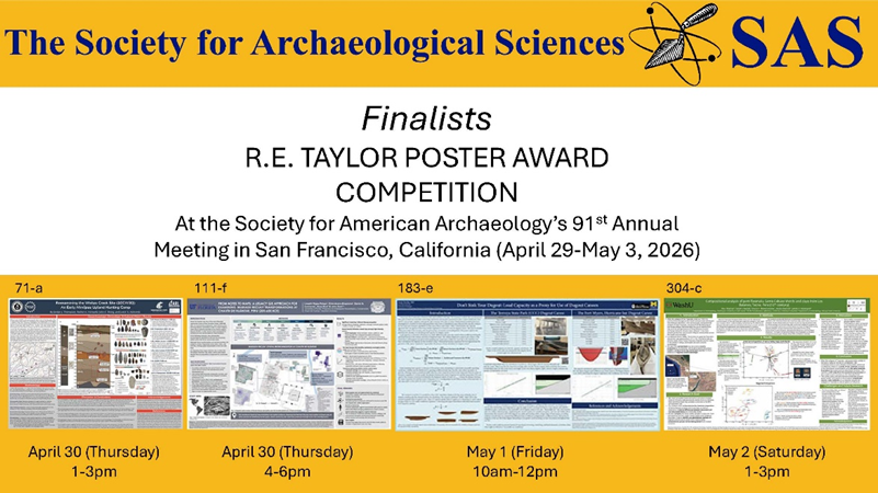
We are pleased to announce four finalists for the R.E. Taylor Poster Award Competition at the Society for American Archaeology’s 91st Annual Meeting in San Francisco, California (April 29-May 3, 2026). If you plan to participate in the meeting, please visit their posters and learn about their fantastic research!
April 30, Thursday Afternoon
1-3pm
Jordan Thompson (Washington State University)
Poster 71-a: Reexamining the Weitas Creek Site (10CW30): An Early Nimíipuu Upland Hunting Camp
4-6pm
Lisseth Rojas-Pelayo (University of Florida)
Poster 111-f: From Notes to Maps: A Legacy GIS Approach for Examining Mariash-Recuay Transformations at Chavín de Huántar
May 1, Friday Morning
10am-12pm
Amy Socha (University of Michigan)
Poster 183-e: Don't Sink Your Dugout: Load Capacity as a Proxy for Use of Dugout Canoes
May 2, Saturday Afternoon
1-3pm
Max Schachar (University of Missouri)
Poster 304-c: Compositional analysis of post-Tiwanaku Sama-Cabuza sherds and clays from Los Batanes, Tacna, Peru (12th century)
- Braden Cordivari
April’s Executive Board Reading Recommendation comes from General Secretary Kate Klesner. Kate has chosen an exciting new paper on organic residue analysis in South America, published open access this month in Archaeological and Anthropological Sciences by Agustina Vázquez Fiorani, Mark Schurr, Valeria Franco Salvi, and Eleanora A. Reber.
In this paper, the authors use lipid residue analysis, a technique that detects ancient organic compounds preserved inside ceramic vessel walls, to reconstruct what people were cooking and eating in three Formative Period villages (200 and 800 CE) in the Tafí Valley of northwestern Argentina. Working with 172 ceramic vessels from villages which each had an ecologically distinct micro-environment, they combine gas chromatography–mass spectrometry (GC-MS), compound-specific isotope analysis (GC-C-IRMS), and bulk isotope analysis of charred food crusts to identify the signatures of food preserved in the ceramics. While organic materials rarely survive in this part of the Andes due to soil acidity and humidity, this research was able to identify preserved lipids in a large enough group of the samples (36%) to be able to demonstrate that neighboring communities, despite sharing socio-material practices, were pursuing meaningfully different subsistence strategies based on their local environments. The villages in the northern valley show stronger signatures of fat processing from camelids and C3/C4 plants, while the southern village exhibits clearer evidence of C3 plant exploitation. This is the first large-scale direct chemical evidence of subsistence micro-diversity within the Southern Andes, and it opens exciting new avenues for understanding how early communities adapted flexibly to their immediate landscapes rather than following a single, uniform model.
Vázquez Fiorani, A., Schurr, M., Franco Salvi, V., Reber, E.A., 2026. Revealing micro-environmental subsistence diversity in the Southern Andes through organic residue analysis in pottery (Tucumán, Argentina, 200–800 CE). Archaeological and Anthropological Sciences 18, 96. https://doi.org/10.1007/s12520-026-02462-0.
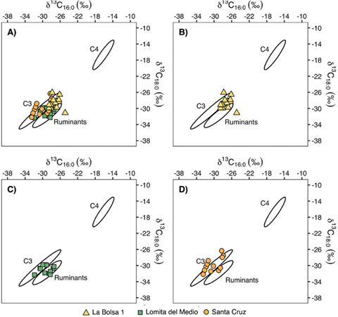
Inter-site patterning of carbon stable isotopes (Vázquez Fiorani et al. 2026, Fig. 6)
- Braden Cordivari
In the spirit of SAS’s upcoming 50th anniversary, we will be looking back at the achievements of our past award winners, sharing spotlights on papers produced from research supported by the SAS Student and ECR Research Support Award. First up is 2021 recipient Petra Vaiglova, Senior Lecturer in Archaeological Science at the School of Archaeology and Anthropology, Australian National University. Petra recently published a paper titled “Transport of animals underpinned ritual feasting at the onset of the Neolithic in southwestern Asia” in Nature Springer: Communications in Earth & Environment as the first author of a team of biologists, archaeologists, and geochemists.
Their study examined seasonal mobility of five wild boar from the Early Neolithic site of Asiab in western Iran using sequential analyses of tooth enamel for oxygen and strontium isotopes and barium concentrations. The team sampled based on microscopic growth patterns identified in the teeth rather than the typical standardized interval (e.g., 1 mm). This method allowed the authors to pinpoint more accurate seasonal patterns of isotopic inputs from changes in eating and drinking. They found that ritual feasting at Asiab relied on the consumption of animals from beyond the immediate catchment of the site, around 70 km away. This result was somewhat surprising, since Asiab is located in an environment where wild boars could have lived locally. These findings shed light on the organization and social connections behind ceremonial feasting during the Neolithic, in particular the investment in bringing animals from beyond the site.
In addition to the main publication, Petra also wrote a 'behind-the-paper' blog post on the Springer Nature Research Communities, a non-technical Perspective for the latest issue of The European Archaeologist, and a public-facing article for The Conversation about this project.
Congratulations to Petra! We hope you enjoy reading her work. Find out more about how to share your work with a Spotlight.
Vaiglova, P., Kierdorf, H., Witzel, C., Falster, G., Joannes-Boyau, R., Wang, Y., Wu, J., Williams, I., Knowles, B., Wu, Y., Bangsgaard, P., Yeomans, L., Richter, T., Darabi, H., 2025. Transport of animals underpinned ritual feasting at the onset of the Neolithic in southwestern Asia. Commun Earth Environ 6, 519. https://doi.org/10.1038/s43247-025-02501-z
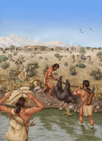
Artist’s representation of the hunting and transport of boars at Asiab. Illustration by Kathryn Killackey
- Braden Cordivari
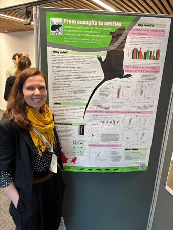
Congratulations to Alice Rose, winner of the Early Career Research Poster Presentation Prize at the United Kingdom Archaeological Sciences Conference (UKAS) 2026, which was held in Bristol this year (March 30-April 2). Alice’s project "From cesspits to castles: isotopic insights into rat dietary ecology and human-rat interactions in Medieval and Post-Medieval Europe" outlined the ongoing carbon and nitrogen isotope analysis being carried out on archaeological rat bones as part of the project "RATTUS: Rats and the Archaeology of Trade, Urbanism, and Disease in Past European Societies” at the University of York, where Alice is currently a Postdoctoral Research Associate.
Alice is a bioarchaeologist specializing in the isotopic analysis of archaeological skeletal remains. As part of this, she is undertaking stable isotope analysis of brown and black rats sourced from archaeological sites from across Europe to help understand the commensal niches of rats and their population dynamics, as well as investigating their role as a novel proxy for key debates in European historical archaeology. As part of the award, Alice receives a £150 prize and complimentary SAS membership. Well done!
- Braden Cordivari
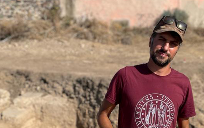
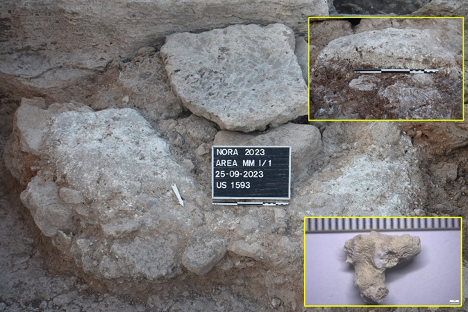
Congratulations to Simone Dilaria, this year’s winner of the SGS Beta-SAS Radiocarbon Dating Award! This annual award is designed to facilitate creative uses of radiocarbon dating, including into geographically and thematically underrepresented areas of research.
Simone’s project is titled “Burning the Sea: Radiocarbon Dating the First Coral Calcination in the Ancient Mediterranean.” In the Phoenician-Punic necropolis of Nora (Sardinia), a unique lime pit produced by calcining murex shells and coral was discovered among Phoenician cremation tombs dating back to the late 9th century BCE. Supported by the SAS Beta-SGS Award, absolute 14C dating of an uncalcined coral residue embedded within the lime will establish a definitive chronology for this pyrotechnological milestone of antiquity. Originating from a marine context, this Early Phoenician feature is calibrated against the more linear Marine20 curve, potentially circumventing the well-known IntCal20 calibration issues of the Hallstatt plateau. Simone explains that this analysis will not only date what appears to be the first instance of coral calcination in the ancient world, but also demonstrate the early introduction of lime technology to the Central-Western Mediterranean, likely facilitated by the Phoenician diaspora.
Simone Dilaria is currently a Researcher in Mineral Resources and Mineralogical-Petrographic Applications for the Environment and Cultural Heritage at the Department of Cultural Heritage, University of Padua. Since September 2025, he also serves as Adjunct Professor at the same institution and at Ca' Foscari University of Venice (School of International Education).
We look forward to following the results of Simone’s research!
- SAS Executive Board Reading Recommendations - "Observations on sample size for lead isotopic analysis of ancient copper alloys"
- SAS Paper Spotlight – Isotopic evidence for changing diet and agriculture in China from the Neolithic to the Early Han period (10-2 ka BP)
- New Student Ambassador – Maren von Mallinckrodt
- SAS Executive Board Reading Recommendations – “Major excursions in sulfur isotopes linked to permafrost change in Eurasia during the last 50,000 years”
- SGS Beta-SAS Radiocarbon Dating Award 2026 - Applications Open