Congratulations to Joris Starke, recipient of the LAC 2024 SAS Poster Award!
Please find Starke's poster and extended abstract posted below:
(Late) Holocene landscape development of the lower Bakırçay plain (Pergamon Micro-Region, western Türkiye) and its modern alteration
Joris Starke1*, Fabian Becker1, Robert Busch1, Bernhard Ludwig2, Moritz Nykamp1, Brigitta Schütt1
1 Freie Universität Berlin
2 German Archaeological Institute, Istanbul Department
* Corresponding author,
The landscape of the lower Bakırçay plain – one of the main E-W-oriented graben-controlled valleys in western Anatolia – that surrounds the ancient city of Pergamon, is highly altered by modern human activity. This is evident in various modifications, including the diversion and canalization of the main rivers, the construction of dams in the headwater areas of their tributaries, and the subsequent expansion of existing and the establishment of new irrigation networks and drainage ditches. While these drainage ditches already existed in the 19th century on a small scale, the main alteration of the river pattern in the Bakırçay plain accelerated with the Third Green Revolution and the general development of irrigation agriculture in the Republic of Türkiye since the late first half of the 20th century. There are currently 14 small to medium scale reservoirs in the Bakırçay catchment mainly used for irrigation purposes, the first being established in 1981. Bakırçay river was diverted and canalized in its course in the eastern lower plain, shortening the course to approx. 75%. This new course now follows the former course of one of its main tributaries to the south. Anabranching or braided rivers were merged and canalized to a straight line, for example at the Ilyacay, the largest tributary of the Bakırçay where the dam of the Yortanlı barajı was built from 1994 to 2011 in the catchment. Additionally, modern land consolidation included remodeling of agricultural parcels including the straightening, merging and levelling of fields, especially at the margins of the plain. This also includes drainage and levelling of old drainage channels (azmak) to gain additional space for agriculture.
In this context, it seems to be clear that the current landscape has little in common with the landscape in antiquity. If we want to understand human-environment-interactions in the past, solid knowledge on the palaeolandscape is required. The late Holocene landscape reconstruction of the lower Bakırçay plain is one of the goals of an ongoing international interdisciplinary research project on the ancient Pergamon micro-region. The project chiefly investigates the transformation of the micro-region between 300 BCE and 300 CE. Of particular interest are the differences between the Hellenistic period and the Roman Imperial period (the latest news can always be found in the project's own blog (dainst.blog/transpergmikro/). From the field of physical geography, contributions to the project include the collection of new geoarchaeological data in combination with geomorphological and sedimentological research with GIS-based analyses as well as the assessment of historical maps and travelogues from the 19th and 20th centuries. Methods used to calculate and analyze DEM derivates include the calculation of Relative Elevation Models (REMs) and flow patterns; these are compared to historical maps and abandoned fluvial landforms still visible in the landscape today. Seismological data and aspects of settlement history are considered in combination with newfound archaeological evidence of settlement patterns, historical land use and human impact on the landscape (Ludwig 2020).
Various hypotheses on the ancient palaeolandscape and on the course of the Bakırçay have been discussed since the late 19th century. One example is the “Dörpfeld-scenario” of a paleo-bay and mouth of the Bakırçay more than 20 km to the north. Some of these hypothesis have been questioned by recent research (Schneider et al. 2013), but can still provide important insights into the extent of landscape change since antiquity. Sedimentological studies provide indications of paleoenvironmental conditions and their development and help to understand historical land use and human influence on the landscape. Although in the (western) Bakırçay plain, six studies on paleoenvironmental conditions are published – together with evaluations of the coastal development-, several questions remain open. This is mainly true for the question during which historical phase human-environmental interactions had the most pronounced impact on sediment dynamics and therefore landscape development. Sediment analyses from the western lower Bakırçay valley show a possible strong influence of the 4.2 ka event on landscape development (partly possibly contemporary to the local onset of settlement activities) with a less pronounced signal at the beginning of antiquity (Yang et al. 2023a; Yang et al. 2023b). In contrast, a meta-analysis of sedimentological analyses has identified a phase of strongly increased sediment dynamics in Roman-Imperial times (Becker et al. 2020).
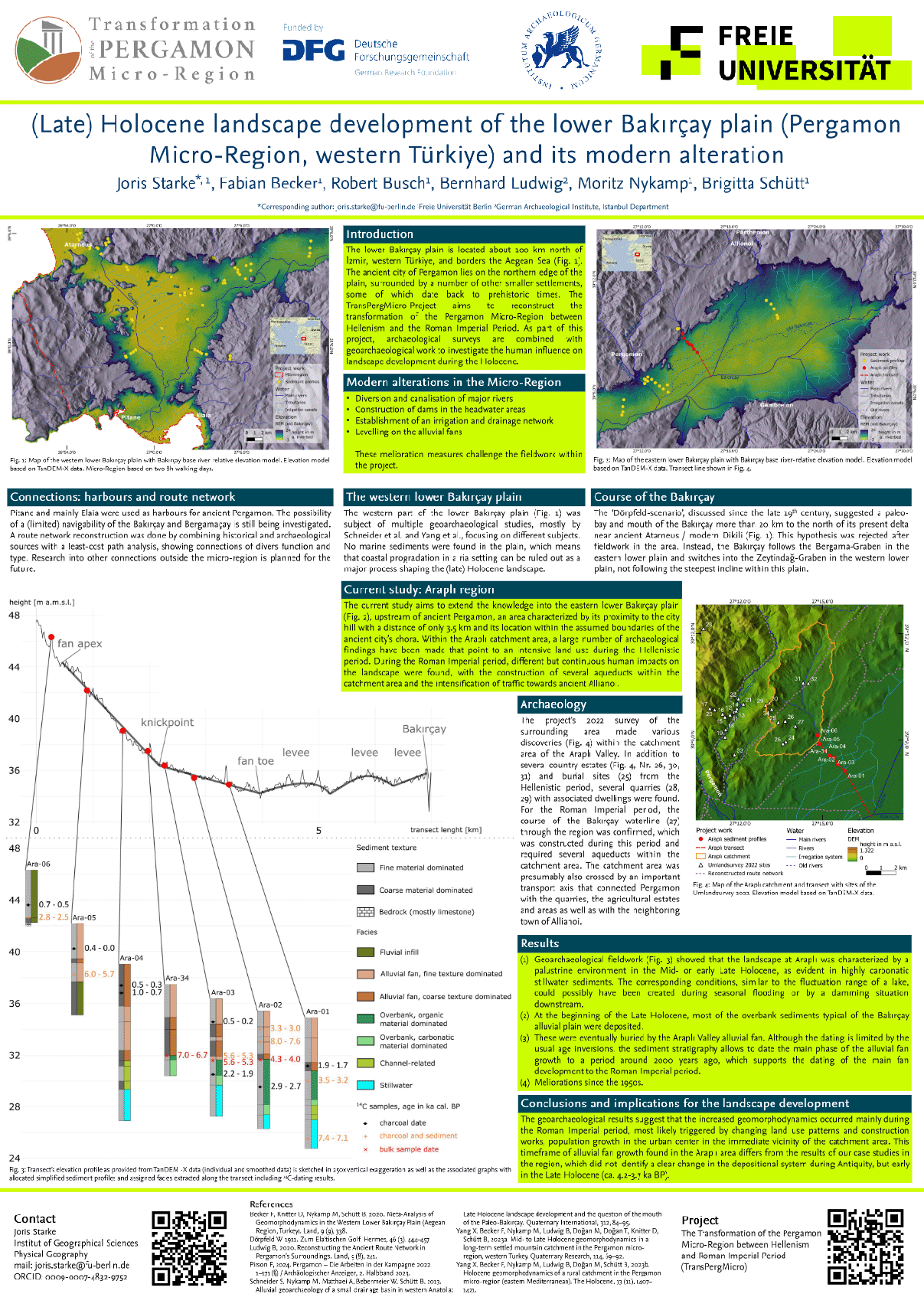
Fig 1: Map of the Araplı catchment with archaeological findings. Elevation based on TanDEM-X data.
Preliminary results of a most recent case study show a clear temporal connection between the growth of the alluvial fan of the Araplı catchment area in the exurbs of Pergamon (Figure 1) and its transformation from Hellenistic to Roman Times. During Hellenistic times, the catchment was mostly used for agricultural purposes and quarrying of Andesite, but also included multiple villas and burial sites along an important route connection towards settlements northeast of Pergamon (Pirson 2024). During Roman-Imperial times, processes of population growth and urbanization led to an increase in land use intensity, increased resource requirements and changes in practices due to cultural change (Becker et al. 2024) as well as urban expansion. This additional land use pressure necessitated agriculture intensification and major construction work, including the construction of monumental buildings in Pergamon and multiple new aqueducts along a water conduit of over 50 km length from the eastern edge of the eastern lower plain towards Pergamon to supply the lower city expansion of which 4 Aqueducts were built in the Araplı catchment. These changes triggered increased sediment dynamics and landscape reshaping within the catchment, leading to a substantial growth of the corresponding alluvial fan. Some of this growth took place over very short periods of time, so it can be assumed that the changes in the landscape must have had a significant influence on historical land use. The possibility of river course diversion due to sediment accumulation in the valley area is currently still being investigated. In contrast to earlier studies mentioned above, these most recent data show a clear influence of the land-use change from the Hellenistic to the Roman Imperial period in a catchment with high proximity to the city of Pergamon. As other studies were mainly conducted in remote catchments these influences are not that clearly observable there. Depending on the geomorphodynamics, sediment characteristics of the Araplı fan allow to differentiate variations of morphodynamics within the small scale of the micro-region and thus contribute to the informative value of other geoarchaeological case studies.
Generally, the landscape of the past Pergamon micro-region seems to have been more diverse than today. Our data therefore help to interpret recent regional studies, including settlement patterns and dynamics, contribute to the interpretation of existing environmental data, provides possible evidence for the so-called crisis of the late Roman Empire, and highlight potential future research areas.
Publication bibliography
Becker, Fabian; Knitter, Daniel; Nykamp, Moritz; Schütt, Brigitta (2020): Meta-Analysis of Geomorphodynamics in the Western Lower Bakırçay Plain (Aegean Region, Turkey). In Land 9 (9), p. 338. DOI: 10.3390/land9090338.
Becker, Fabian; Knitter, Daniel; Walser, Andreas Victor; Ludwig, Bernhard; Tozan, Murat; Schütt, Brigitta (2024): Understanding geomorphodynamics in the Pergamon micro-region from a socio-ecological perspective. In The Holocene. DOI: 10.1177/09596836241259772.
Ludwig, Bernhard (2020): Reconstructing the Ancient Route Network in Pergamon’s Surroundings. In Land 9 (8), p. 241. DOI: 10.3390/land9080241.
Pirson, Felix (2024): Pergamon – Die Arbeiten in der Kampagne 2022. 1–171 (§) Seiten / Archäologischer Anzeiger, 2. Halbband 2023. DOI: 10.34780/DCX6-X50B.
Schneider, Steffen; Nykamp, Moritz; Matthaei, Albrecht; Bebermeier, Wiebke; Schütt, Brigitta (2013): Alluvial geoarchaeology of a small drainage basin in western Anatolia: Late Holocene landscape development and the question of the mouth of the Paleo-Bakırçay. In Quaternary International 312, pp. 84–95. DOI: 10.1016/j.quaint.2013.05.043.
Yang, Xun; Becker, Fabian; Nykamp, Moritz; Ludwig, Bernhard; Doğan, Mehmet; Doğan, Turhan et al. (2023a): Mid- to Late Holocene geomorphodynamics in a long-term settled mountain catchment in the Pergamon micro-region, western Turkey. In Quat. res. 114, pp. 69–92. DOI: 10.1017/qua.2022.73.
Yang, Xun; Becker, Fabian; Nykamp, Moritz; Ludwig, Bernhard; Doğan, Mehmet; Schütt, Brigitta (2023b): Holocene geomorphodynamics of a rural catchment in the Pergamon micro-region (eastern Mediterranean). In The Holocene 33 (11), pp. 1407–1421. DOI: 10.1177/09596836231185837.